
West Point Gold Corp. (TSXV: WPG) (OTCQX: WPGCF) (FSE: LRA0) announced the results from five drill holes within the high-grade Northeast (“NE”) Tyro zone at its flagship Gold Chain Project in Arizona. Hole GC26-169 was a reverse circulation (“RC”) hole that intersected 51.9 metres (“m”) of 2.5 grams per tonne (“g/t”) gold (“Au”) from 276m, including 21.4m at 4.72 g/t. This intercept has an estimated true width (“TW”) of 38m. These holes continue to extend the zone at NE Tyro down-dip where it remains open to depth and to the northeast towards the prospective Frisco Graben target.
The Company is reporting assay results for five drill holes (1,542m), GC26-142, GC26-157, GC26-159, GC26-165 and GC26-169. Results from 14 holes representing 4,378m of the recently completed 21,079m program are still pending. All results from Tyro Main and NE Tyro are expected to contribute to the Company’s upcoming maiden resource estimate to be released later in 2026.
Highlights:
- Hole GC26-169 (Line 1100) intersected 51.9m at 2.5 g/t Au, including 21.4m at 4.72 g/t Au beginning approximately 300m below surface;
- Hole GC26-157 (Line 1050) cut 32.0m at 3.4 g/t Au about 60m below GC25-085 (29m at 5.24 g/t Au);
- Hole GC26-159 (Line 1200) intersected 36.5m at 2.79 g/t Au, including 9.1m at 6.46 g/t Au within the NE Tyro vein at about 350m below surface;
- Results from all three sections (L1050, L1100 and L1200) indicate that the NE Tyro vein is well developed up to 350m below the surface;
- NE Tyro remains open to depth and to the northeast towards the Frisco Graben.
“Drilling at NE Tyro continues to demonstrate consistent grades and widths. This set of results also confirms consistent mineralization in multiple sections and bodes well for the pending maiden resource. As we move towards the Frisco Graben, we have been able to define the gold zone in areas with little to no surface expression. Drilling continues to validate the depth potential in this area, as we have demonstrated gold mineralization vertically over 300m at NE Tyro, supporting our view that NE Tyro remains open at depth. We remain on track to deliver the maiden resource at Tyro later this year,” stated Derek Macpherson, President and CEO.
Table 1: Drill Results
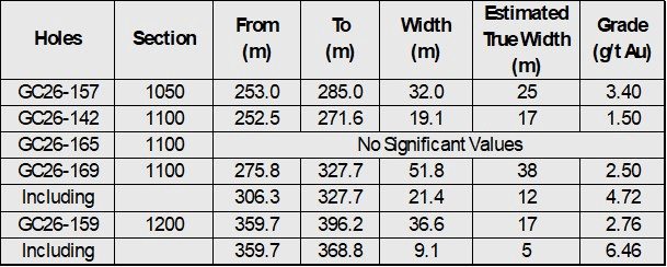
Figure 1. Plan view of the Main Tyro vein showing geology and drilling conducted in 2021, 2023, 2024, 2025, and 2026. Note the location of Hole Nos. GC26-157 (L1050), GC26-142, GC26-165, GC26-169 (L1100), and GC26-159 (L1200).
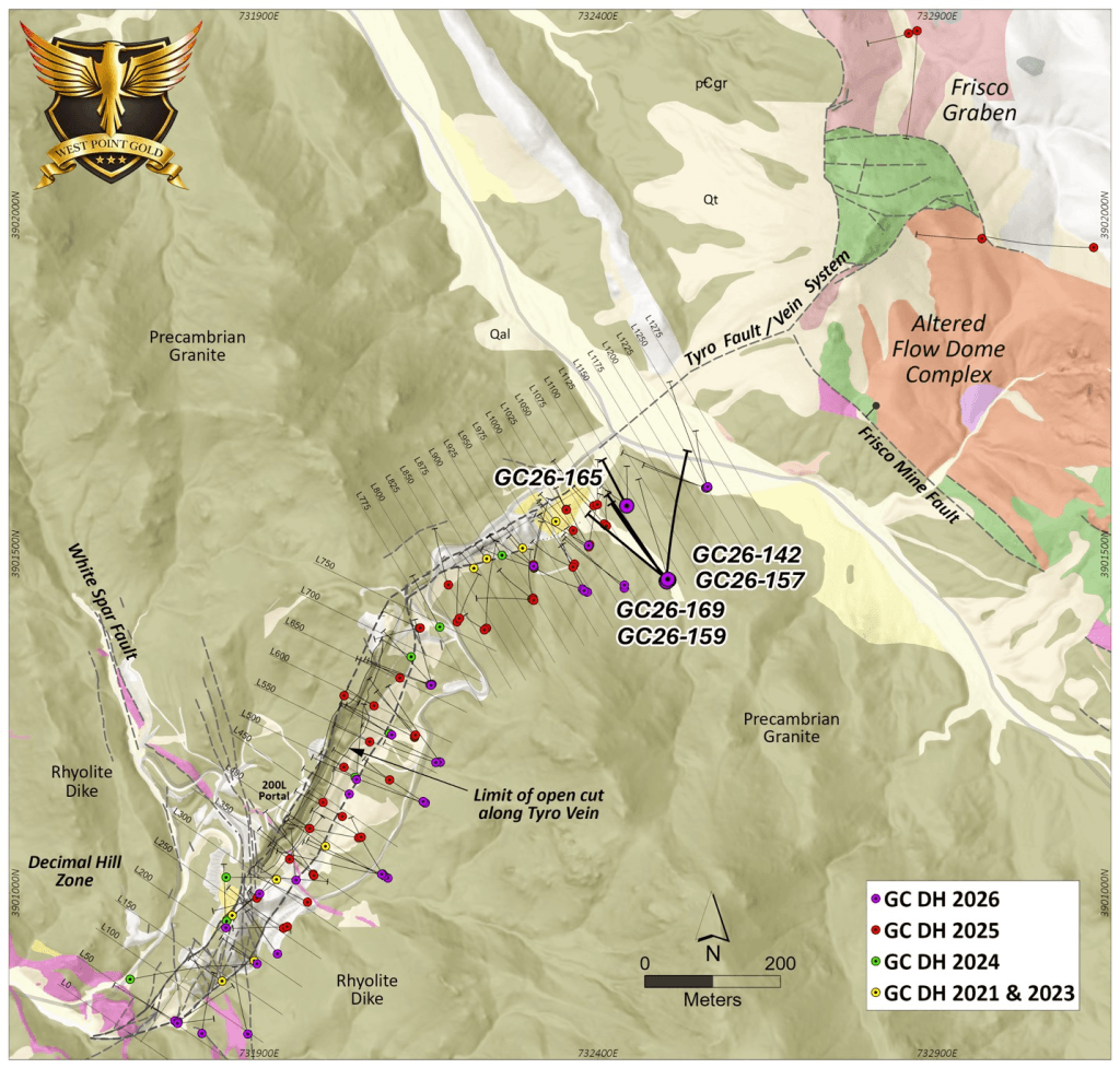
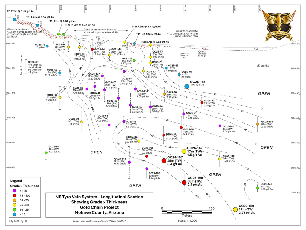
Figure 2. Longitudinal perspective of the Tyro NE zone contoured GT (g/t Au X estimated true thickness) highlighting the results from Holes GC26-142, GC26-157, GC26-159, GC26-165 and GC26-169.
Line 1050 (GC26-157)
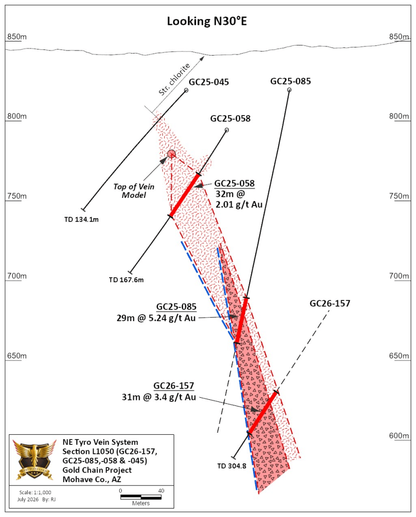
Section L1050 (Figure 3) reveals that the NE Tyro vein system is not exposed at the surface and is considered to be ‘blind’. Holes GC25-045 and GC25-046 confirmed this and identified vein-related alteration but without quartz vein and associated gold values. The exposure of the gold zone at the surface a short distance to the southwest (L1025) suggests a northeast-trending plunge at about 30 degrees. This point (Top of the Vein Model) is shown in Figure 3.
Drill sections to the southwest, where gold mineralization is documented in surface exposures, i.e. Lines 875 to 1025, reveal robust gold deposition up to 300m vertically (down-dip) that remains open to depth. Sections to the northeast of Line 1050 show the top of the ‘gold zone’, which begins below the surface; this zone of gold deposition continues deeper as exploration proceeds to the northeast.
Hole GC26-157 intersected 32.0m at 3.4 g/t Au from 253 to 285m and contained 9.1m at 7.85 g/t Au, including a thick zone of vein and hydrothermal breccia (>50% vein). The elevation of this intercept is about 620m ASL and about 175m below the ‘top’ of the vein system and 230m below surface (Figure 3).
Figure 3. Geologic section drawn along Line 1050 showing vein and spatial relation between GC26-157 and GC25-058 and GC25-085.
Line 1100 (GC26-142, GC26-165 and GC26-169)
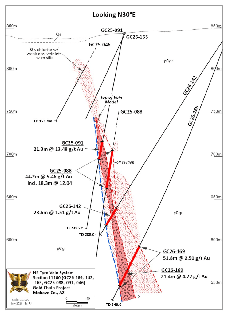
Section L1100, shown in Figure 4, contains Holes GC26-165, GC26-142 and GC26-169. These holes were designed to test the vein zone both above and below Holes GC25-088 and GC26-091, where drilling revealed 44.2m at 5.46 g/t Au and 21.3m at 13.48 g/t Au, respectively. Hole GC26-142 crossed the vein system about 40m below Hole GC25-088 and intersected 23.6m at 1.51 g/t Au. The upper hole, GC26-165 (core), drilled to identify the upper limit of the vein system, identified several metres of quartz veinlets and local breccia with anomalous, low-level gold values. Alteration of the Precambrian granite across this zone consisted of moderate to strong illite-pyrite alteration replacing chlorite in the propylitic selvage. This hole, shown in Figure 4, better defines the upper limit of gold mineralization.
Hole GC26-169 crossed the vein system about 60m below Hole GC26-142 and encountered 51.9m at 2.5 g/t Au from 275.8 to 327.7m; this envelope contained 21.4m at 4.72 g/t Au in mostly quartz ‘stockwork and breccia’. Relative to Hole GC26-142 (Figure 4), the mineralized package appears to be widening at depth and remains open below the 550m ASL elevation or about 150m below the upper extent of the vein package and about 300m below surface.
Figure 4. Geologic section drawn along Line 1100 showing vein and spatial relation between GC26-142, GC26-165 and GC26-169 and GC25-088 and GC25-091.
Line 1200 (GC26-159)
Hole GC26-159 was designed to test the down-dip extension of gold mineralization intersected in Holes GC26-140, GC26-145, GC26-147 and GC26-151 (see press release here). Section L1200 (Figure 5) reveals an interpretation showing the top of the vein model at an elevation of about 725m ASL, about 125m below surface, which is consistent with sections to the southwest (Figures 3 and 4). The uppermost hole on this section, GC26-140, intersected 18.3m at 6.05 g/t Au (TW = 15m) while GC26-145, about 60m down-dip, cut 28.9m at 1.22 g/t Au (TW ~ 16m). Hole GC26-159, about 100m deeper, traversed 36.6m (TW ~ 17m) at 2.79 g/t Au, containing 9.14m at 6.46 g/t Au. The vein here appears to be steeper than observed in sections to the southwest. This intercept is about 150m below the top of the vein envelope and well above vein depths observed to the south; the vein system remains open.
Figure 5. Geologic section drawn along Line 1200 showing vein and spatial relation between GC26-159 and GC26-147 and GC26-151.
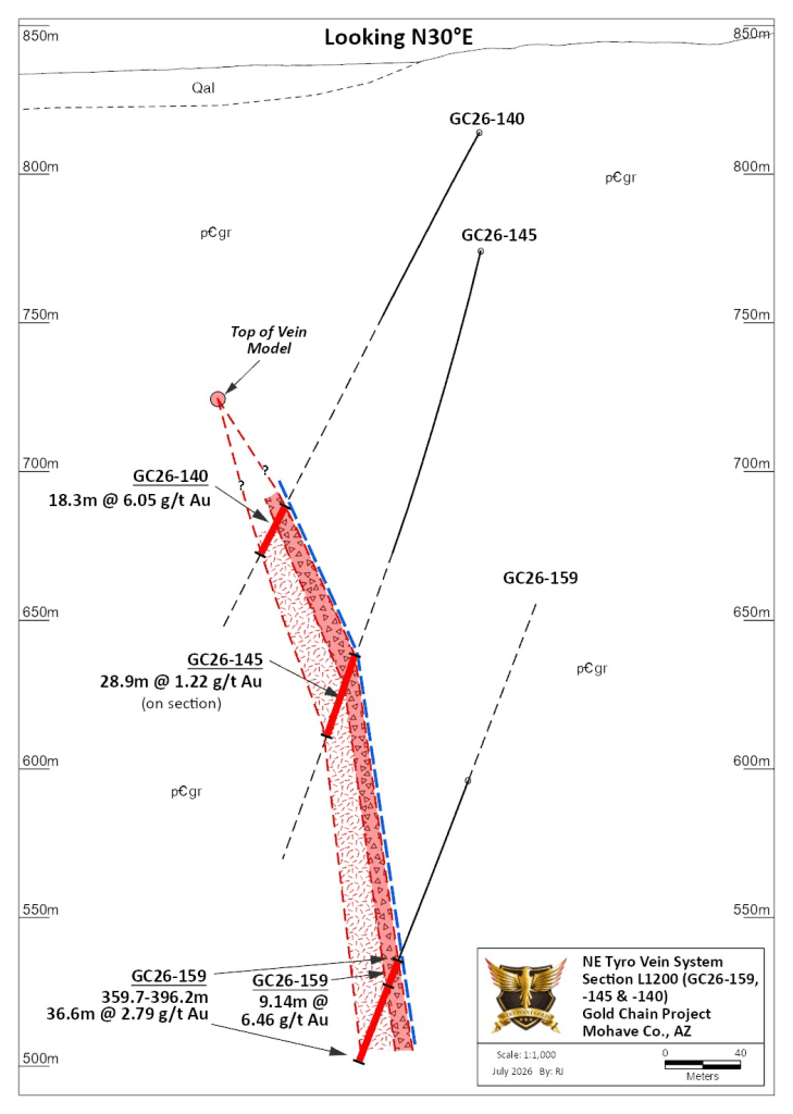
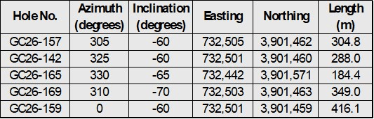
Table 2: Drill hole locations and descriptions
Qualified Person
Robert Johansing, M.Sc. Econ. Geol., P. Geo., the Company’s Vice President, Exploration, is a qualified person (“QP”) as defined by NI 43-101 and has reviewed and approved the technical content of this press release. Mr. Johansing has also been responsible for overseeing all phases of the drilling program, including logging, cutting, labelling, bagging and transport from the project to American Assay Laboratories (AAL) of Sparks, Nevada. Reverse Circulation (RC) drill holes have a diameter of about 10cm (~4″), and samples have an approximate weight of 5 to 10kg. Core size is HQ (2.5″/63.5mm) and is logged, photographed and cut at the Company’s Bullhead City sampling facility, including the insertion of blanks and standards. All samples are packaged for shipment at the facility and trucked to AAL in Reno. Samples were then dried, crushed and split, and pulp samples were prepared for analysis. Gold was determined by fire assay with an ICP finish, and over-limit samples were determined by fire assay and gravimetric finish. Silver plus 15 other elements were determined by Aqua Regia ICP-AES (IM-2A16), and over-limit samples were determined by fire assay and gravimetric finish. Both certified standards and blanks were inserted on site along with duplicates, standards and blanks inserted by American Assay. The results summarized above have been carefully reviewed with reference to the QA/QC results. Standard sample chain of custody procedures were employed during drilling and sampling campaigns until delivery to the analytical facility.