West Point Gold Corp. (TSXV: WPG) (OTCQX: WPGCF) (FSE: LRA0) announced the commencement of its fully funded 30,000-metre drill program at its flagship Gold Chain Project in Arizona. At the program’s peak, the Company expects to have three drill rigs on-site: two reverse circulation (“RC”) drill rigs and one diamond core drilling rig. One rig is currently on-site; the other two are expected before year-end. The Company now expects to deliver a maiden mineral resource estimate in Q1 2027.
Highlights
- 30,000-Metre Drill Program Commenced: Drilling is underway as part of a substantial exploration campaign designed to expand known gold mineralization at Tyro, increase our knowledge at known satellite targets like Black Dyke and Sheep Trail, and test new targets.
- Accelerating Exploration Activity: To date, only 30,000m have been drilled at Gold Chain; this program represents a potential doubling of the metres drilled to date and has the potential to meaningfully expand known mineralization at Tyro while increasing our knowledge of the multiple satellite targets that have been identified.
- Strong Financial Position: Since June 30, 2026, when the Company reported working capital of C$25.1 million, there have been C$4.7 million in warrant exercises. All warrants expiring in 2026 have now either been exercised or expired. The Company’s strong balance sheet fully funds the planned drill program and other development work currently planned for the project.
- Updated Maiden Resource Timing: The Company now expects the maiden resource for Tyro Main Zone and the high-grade Northeast (NE) Tyro zones to be delivered in Q1 2027. The change in timing is a result of delayed duplicate assay results required by the independent technical consultant engaged to model the deposit (“Technical Consultant”) as part of its QA/QC procedures, together with the decision to incorporate some key early drill holes from the current program, as recommended by the Company’s geology team and the Technical Consultant.
“While we have had significant success at Gold Chain to date, it remains early days. This 30,000m program will roughly double the metres drilled at Gold Chain. It is fully funded, and its goal is simple: expand Tyro and test the satellite targets. Every phase of drilling at Gold Chain has demonstrated that the system is growing and that further drilling is warranted, this remains the case,” stated Derek Macpherson, President and CEO.
Update on Resource Timing
West Point Gold is revising the timing for publication of its maiden mineral resource estimate at Tyro Main Zone and NE Tyro; it is now planned for Q1 2027.
The Technical Consultant completing the resource work for West Point Gold requires several duplicate assays to be completed at a different lab than the original assays. This is a normal part of the QA/QC verification procedures, and the samples have been identified and sent to the lab. Unfortunately, as has been seen across the industry, these duplicate assay results have been delayed.
Additionally, the Company’s geology team working with the Technical Consultant has recommended several drill holes that, are expected to have an impact on the maiden resource.
Figure 1: Gold Chain Property Map Highlighting Geology and 2026-2027 Target Areas.
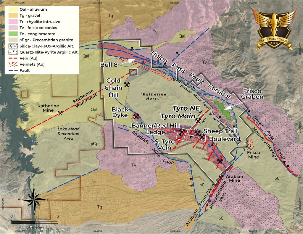
Areas Targeted in the Ongoing 30,000m Drill Program:
Northeast (“NE”) Tyro
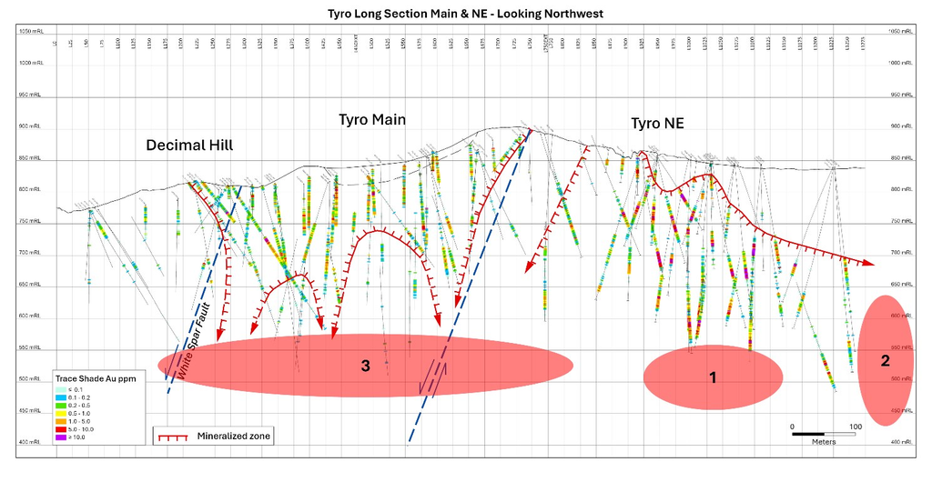
The best drill results at the Gold Chain project to date have been from NE Tyro. This shallow zone has returned significant grades and widths. Drilling in 2026 materially expanded this zone along strike and at depth. The next drilling phase at this zone will focus on pushing gold mineralization deeper and below some of the most recent high-grade holes (Target Area 1 – Figure 2). Additionally, the zone remains open to the northeast towards the Frisco Mine fault, the southwest boundary of the Frisco Graben target. West Point Gold believes that the Frisco Mine fault may serve as a regional conduit for mineralizing fluids. The intersection of the Tyro vein system and the Frisco Mine fault is considered very prospective and is highlighted by strong kaolinite alteration (high-level) and lower magnetic susceptibility (magnetite destruction) along the projection of the Tyro vein system. The target areas at NE Tyro are shown in Figure 2 (Target Area 2). The amount of drilling at NE Tyro will be dependent on results.
Tyro Main Zone
Tyro Main is also expected to contribute to the maiden resource. Recent drilling at the Tyro Main Zone demonstrated weakening gold grades with depth; however, the alteration in those drill holes appears to more closely resemble what is typically seen above a low-sulphidation epithermal gold zone, not below. As such, the plan is to continue testing the Tyro Main zone to depth (Target Area 3 – Figure 2) utilizing two strategies: first, by stepping down below the 2026 intercepts and, second, by pushing the limits of Target Area 1 to the southwest and beneath the current Tyro Main mineralized zone.
Figure 2: Tyro Long Section showing drill hole traces and intercepts. Also shown are the generalized targets (#1 – #3) in order of priority for the upcoming drilling campaign.
Black Dyke Target
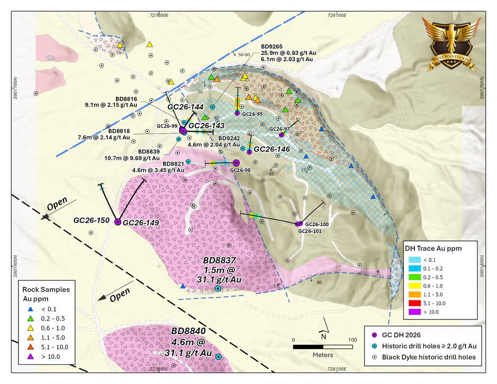
Black Dyke has evolved from a historical prospect into a credible second potential resource-development area at Gold Chain but will not be included in the maiden resource. Its shallow, low-angle geometry, along with its oxidized nature, could make it particularly attractive for potential open-pit development if additional drilling establishes sufficient scale and continuity. The zone is located approximately 4 km west of the Tyro Main Zone along the Roadside Mine fault, which borders the southwest flank of the Katherine Horst. Alteration and vein textures observed in the shallow drilling suggest additional potential exists at depth, supported by recently acquired historical drilling.
Initial RC drilling has defined a shallow-dipping zone extending for at least 200m along strike and approximately 250m down-dip. Importantly, mineralization begins at or the near surface, is largely oxidized, and remains open to the west and down-dip to the southwest. Initial drilling returned encouraging, relatively consistent widths and grades, highlighted by 36.6 m at 1.04 g/t Au (GC26-095) from surface, 21.3 m at 0.92 g/t Au (GC26-098), 7.6 m at 1.56 g/t Au (GC26-099), and 12.2 m at 1.09 g/t Au (GC26-101).
Drilling is planned to follow-up on the high-grade historical results and continue expanding the zone towards the Roadside Mine fault.
Figure 3: Geologic Map of the Black Dyke prospect showing historical and 2026 (purple) drill holes along with surface samples. Please note historical holes BD8837 and BD8840 with 1.5 to 4.6m of >1 opt Au.
Sheep Trail
Sheep Trail was the highest grade mine in the Katherine (North Oatman) District when it was mined over 100 years ago. Recent drill results suggest that it is a third potential resource-development area at Gold Chain. Located approximately 600 metres south of the Tyro Main Zone, drilling at Sheep Trail has intersected broad zones of shallow gold mineralization within an extensive structural corridor that can be traced for more than one kilometre. Recent drilling has returned encouraging near-surface intersections, including 32.0 metres grading 1.05 g/t Au from only 9.1 metres depth (GC26-106), 19.8 metres grading 1.42 g/t Au from 51.8 metres (GC26-111), and 7.6 metres grading 2.41 g/t Au from 61.0 metres (GC26-113).
Importantly, mineralization remains open along strike, providing opportunity to expand the system through additional drilling. Continued drilling will focus on expanding the known mineralized zones, testing extensions along the broader Banner-Sheep Trail trend and evaluating the potential for Sheep Trail to contribute meaningful additional ounces to the Gold Chain resource base.
Bull 8 Target
Bull 8 is an early-stage gold discovery located approximately 6 km northwest of the Tyro Zone. The prospect occurs along the northwest-trending Union Pass Fault Corridor characterized by strongly sheared, brecciated and altered Precambrian granite cut by fault-bounded dikes. Historical pits, adits and trenches occur throughout the prospect, with surface samples returning up to 2.09 g/t Au. Widespread quartz veining, hydrothermal alteration and anomalous gold occur along the broader Union Pass Fault Corridor, which extends for roughly 12 km across the property. The fault corridor is interpreted as a major pre-, intra- and post-mineral structural control on the broader Gold Chain mineralizing system. The 2026 drilling consisted of six RC holes totalling 856 m, with gold mineralization intersected in every hole. The standout result was GC26-136: 21.4 m at 1.01 g/t Au, including an estimated 18 m true width, beginning at 71.6 m depth. A second hole, GC26-130, returned 12.2 m at 0.41 g/t Au from only 6.1 m depth, demonstrating that mineralization also occurs close to surface.
Drilling is expected to follow-up on the 2026 results and expand the zone to depth and along strike.
Frisco Graben
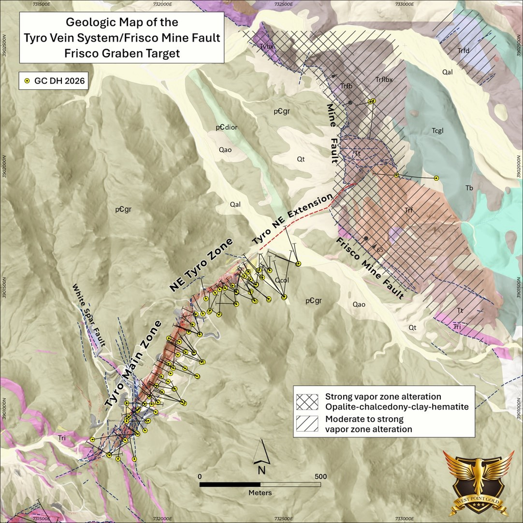
The Frisco Graben represents one of the largest and most compelling discovery opportunities at the Gold Chain Project. Located immediately northeast of the high-grade, Northeast Tyro zone, Frisco Graben is a large-scale, concealed low-sulphidation epithermal gold target extending approximately four kilometres in length and up to 750m in width. The target lies at the intersection of the northeast extension of the mineralized Tyro structural corridor and the regionally significant northwest-trending Frisco Mine Fault, creating a highly prospective structural setting for developing a substantial gold system (Figure 4).
Exploration at Frisco has identified widespread, intense hydrothermal alteration associated with rhyolite dikes, flow domes, volcanic rocks and major graben-bounding structures. Initial drilling encountered broad zones of deeply oxidized kaolinite-silica-hematite alteration in the hanging wall of the Frisco Mine fault. Prior drilling intersected anomalous gold and elevated mercury, an important pathfinder element in low-sulphidation epithermal systems. Hyperspectral and geochemical studies indicate that the initial drill holes remained within the upper, steam-heated portion of the hydrothermal system, suggesting that the prospective gold-bearing boiling zone may occur deeper and remains largely untested.
Drilling conducted in 2026 at NE Tyro reveals that gold mineralization is extending toward and plunging into the footwall of the Frisco Mine fault. This provides West Point Gold the opportunity to follow mineralization into and beneath the Frisco Graben domain. Recognizing the complex structural and hydrothermal history at Gold Chain, determining the relationship between gold mineralization in the footwall and steam-generated alteration in the hanging wall of the Frisco Mine fault is an important objective in the 2026-2027 drilling campaign.
Figure 4: Geologic Map of the intersection of the Tyro Vein System and the Frisco Mine fault, revealing the spatial relationship between gold mineralization and steam-generated alteration in the Frisco Graben target area.
Qualified Person
Robert Johansing, M.Sc. Econ. Geol., P. Geo., the Company’s Vice President, Exploration, is a qualified person (“QP”) as defined by NI 43-101 and has reviewed and approved the technical content of this press release.
About West Point Gold Corp.
West Point Gold is an exploration and development company focused on unlocking value across four strategically located projects along the prolific Walker Lane Trend in Nevada and Arizona, USA, providing shareholders with exposure to multiple discovery opportunities across one of North America’s most productive gold regions. The Company’s near-term priority is advancing its flagship Gold Chain Project in Arizona.
West Point Gold is a market awareness client of Capital 10X. For more information, including potential conflicts of interest please see our Content Disclaimer